

GPS triangulation in vehicles is defined as the process of calculating a vehicle’s exact position by measuring distances from multiple orbiting satellites, using a method called trilateration. The term “triangulation” is widely used but technically inaccurate. The correct industry term is trilateration, and understanding the difference matters if you want to know how GPS determines position in your car. At least four satellites are required to produce a reliable fix, accounting for latitude, longitude, altitude, and a critical timing correction. Thatcham Trackers supplies certified devices that depend on this technology to deliver the recovery performance that UK insurers demand.
What is trilateration and how does it differ from GPS triangulation?
Trilateration uses distances, not angles, to calculate position. Classical triangulation measures the angles between known points to find an unknown location. That works well on flat maps with physical reference points, but it is impractical when your reference points are satellites orbiting at 20,200 km altitude. Measuring angles to a satellite from a moving vehicle receiver is not feasible. Measuring the travel time of a radio signal is.
Trilateration works by calculating how long a satellite’s signal takes to reach the receiver. Since radio signals travel at the speed of light, the receiver converts that travel time into a distance. With one satellite, you know you are somewhere on a sphere of that radius. With two, you are on a circle where two spheres intersect. With three, you are at one of two points. The fourth satellite resolves ambiguity and, critically, corrects a timing error in the receiver’s internal clock.
The table below shows the key differences between the two methods.
| Feature | Triangulation | Trilateration |
|---|---|---|
| Measurement type | Angles | Distances |
| Reference requirement | Known angles from fixed points | Known positions of satellites |
| Practical for satellite nav | No | Yes |
| Satellites required | Not applicable | Minimum four |
| Used in GPS systems | No | Yes |
Pro Tip: When a car enthusiast or journalist says “GPS triangulation,” they mean trilateration. Both terms appear in everyday use, but trilateration is what your satnav and vehicle tracker actually perform.
How do GPS satellites and vehicle receivers determine location?
The US GPS constellation operates with 31 active satellites orbiting at approximately 20,200 km altitude. That number ensures at least four satellites are visible from almost any point on Earth at any time. Each satellite continuously broadcasts two pieces of information: its exact orbital position and a precise timestamp.
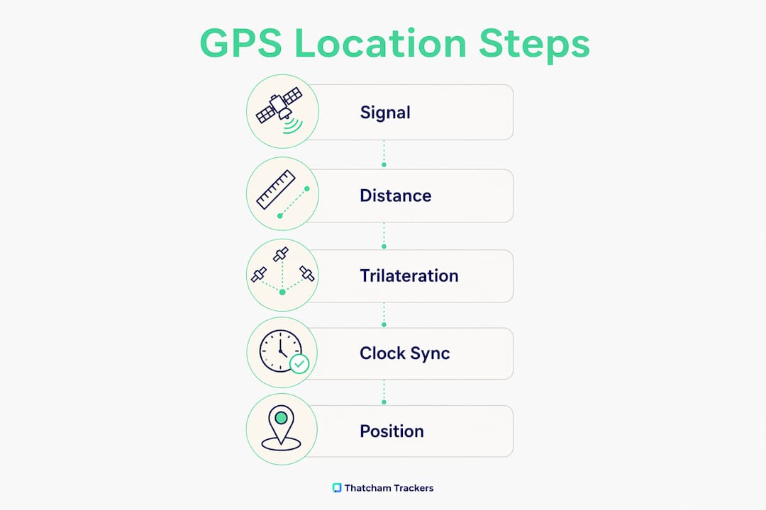
The GPS receiver in your vehicle picks up those signals and measures how long each one took to arrive. That travel time, multiplied by the speed of light, gives the distance to each satellite. The receiver then solves a set of simultaneous equations to find the single point in space that satisfies all the measured distances at once.
The step-by-step process works as follows.
- The vehicle’s GPS receiver picks up signals from four or more satellites.
- Each signal carries the satellite’s position and the time it was sent.
- The receiver calculates the travel time for each signal.
- Travel time is converted to distance using the speed of light.
- Three distances place the receiver at one of two points in 3D space.
- The fourth satellite signal corrects the receiver’s internal clock drift mathematically.
- The receiver outputs a confirmed latitude, longitude, and altitude.
The clock correction step is the one most people overlook. A quartz clock inside the receiver drifts by tiny fractions of a second. At the speed of light, even a microsecond of error translates to roughly 300 metres of positional error. The fourth satellite solves that problem algebraically, removing the need for an expensive atomic clock in every device.
What factors affect GPS accuracy in vehicles?
Modern GPS vehicle trackers achieve 5–10 metres accuracy in open-sky conditions. In dense urban environments, accuracy degrades to over 30 metres due to signal reflections off buildings, a problem known as multipath error. That gap matters significantly for vehicle recovery operations, where a 30-metre error could place a stolen car in the wrong street or car park.
Several factors influence how well a vehicle’s GPS receiver performs.
- Satellite geometry: More satellites in view, spread across the sky, produce better accuracy. A cluster of satellites in one direction gives a weaker fix.
- Multipath interference: Signals bouncing off tall buildings or car park structures arrive at the receiver slightly delayed, distorting the distance calculation.
- Atmospheric conditions: The ionosphere and troposphere slow radio signals unpredictably, introducing small errors that correction algorithms partially offset.
- Signal obstruction: Tunnels, underground car parks, and dense tree cover block satellite signals entirely, causing a temporary loss of fix.
- Receiver quality: Consumer-grade chips perform differently from the certified modules used in Thatcham-approved trackers.
The table below summarises typical accuracy by environment.
| Environment | Typical accuracy |
|---|---|
| Open motorway | 5–10 metres |
| Suburban roads | 10–20 metres |
| Dense urban centre | 30+ metres |
| Underground or tunnel | No GPS fix |
Additional satellite constellations improve reliability. Russia’s GLONASS and the European Union’s Galileo system operate independently of US GPS. A receiver that uses all three constellations simultaneously has more satellites to choose from, improving geometry and reducing the impact of any single blocked signal.
Pro Tip: If your vehicle is frequently parked in underground car parks or city centres, choose a tracker that combines GPS with VHF technology. VHF signals penetrate structures where GPS cannot reach, maintaining tracking continuity.
How do modern vehicle GPS trackers transmit location data?
The GPS module inside a tracker calculates position independently. That position fix is then transmitted over a cellular network, typically using a built-in SIM card on a 4G LTE connection, to a monitoring centre server. The intelligence of the system sits primarily in that server and the Secure Operating Centre (SOC) that monitors it, not solely in the hardware fitted to the vehicle.
Thatcham-certified trackers fall into distinct categories based on their monitoring capability. S7 trackers are reactive systems: they report location when queried or when triggered by an alert. S5 trackers are proactive, using Automatic Driver Recognition (ADR) to detect when an unauthorised driver is operating the vehicle and alerting the SOC without any input from the owner. S5+ trackers add remote immobilisation, allowing the SOC to disable the vehicle safely once police have confirmed its location.
Thatcham-certified trackers also employ anti-jamming technology that combines GPS, GSM, and VHF frequencies. Thieves increasingly use GPS jammers to block satellite signals during a theft. VHF operates on a completely different frequency band and cannot be blocked by the same device, so the tracker continues to report location even when the GPS signal is suppressed.
Key functions of a certified vehicle tracker include:
- Continuous or triggered location reporting via 4G LTE cellular networks
- 24/7 SOC monitoring with direct police liaison capability
- ADR alerts when an unrecognised driver is detected (S5 and S5+)
- Remote immobilisation on SOC instruction (S5+)
- Anti-jamming protection combining GPS, GSM, and VHF signals
Pro Tip: Ask your tracker supplier which SOC monitors your device and whether it holds a BS 8418 certification. An uncertified monitoring centre reduces the practical value of even the best hardware.
What are the certification requirements for vehicle GPS trackers in the UK?
Only professionally installed, Thatcham-certified trackers satisfy UK insurance requirements. A self-fitted consumer GPS device, regardless of its technical specification, does not qualify. Thatcham Research, the UK’s central automotive risk intelligence organisation, independently tests and certifies vehicle security systems. Insurers use those ratings to assess theft risk and set premiums.
The three main certified categories carry distinct capabilities and insurance implications.
- S7: Baseline insurance-approved tracking. Reactive monitoring, SOC support, and GPS location reporting. Suitable for most standard insurance requirements.
- S5: Proactive monitoring with ADR. The system detects unauthorised use automatically, reducing the window between theft and police response.
- S5+: All S5 features plus remote immobilisation. The highest level of certified protection currently available.
A common misconception is that any GPS tracker with live tracking qualifies for insurance purposes. It does not. The Thatcham certification process tests the full system: hardware, software, monitoring centre response times, and installation standards. Fitting a certified device also requires a qualified engineer, which protects the integrity of the installation and validates the warranty.
Drivers of high-value or high-risk vehicles, including prestige cars and performance models, frequently find that insurers require an S5 or S5+ device as a condition of cover. Choosing the correct category from the outset avoids policy complications at the point of claim.
Key takeaways
GPS vehicle tracking relies on trilateration, not triangulation, requiring signals from at least four satellites to calculate position, correct timing errors, and deliver the accuracy that certified security systems depend on.
| Point | Details |
|---|---|
| Trilateration, not triangulation | GPS measures distances from satellites, not angles; four satellites are the minimum for a reliable fix. |
| Clock correction is critical | The fourth satellite signal corrects receiver clock drift, preventing positional errors of hundreds of metres. |
| Accuracy varies by environment | Open-sky accuracy reaches 5–10 metres; urban canyons degrade this to 30+ metres due to multipath errors. |
| Certified trackers use multiple technologies | Thatcham-approved devices combine GPS, GSM, and VHF to maintain tracking even when jammers are active. |
| Professional installation is mandatory | Self-fitted consumer trackers do not meet UK insurance standards; only certified, professionally installed devices qualify. |
GPS technology and vehicle security: a view from Thatcham Trackers
Most car owners treat GPS as a given. The satnav works, the tracker reports a location, and the technical detail stays invisible. That invisibility is exactly where problems begin.
Understanding how trilateration actually functions changes how you evaluate a tracker. A device that relies solely on GPS will fail the moment a thief activates a jammer. A device that adds VHF to the mix continues reporting because it operates on a frequency the jammer cannot touch. That distinction is not a marketing claim. It is a direct consequence of how satellite positioning works and where its physical limits lie.
Vehicle theft in the UK has grown more technical. Relay attacks, signal jamming, and keyless entry exploitation are now standard tools for organised gangs. The response has to match that sophistication. Thatcham Research’s certification process exists precisely to test whether a device and its monitoring infrastructure can perform under those conditions, not just in ideal open-sky environments.
The advice here is straightforward. Choose a certified device in the correct category for your vehicle and insurer. Understand what your SOC does when an alert triggers. And recognise that the GPS module is only one component in a system whose real strength lies in the monitoring, the anti-jamming capability, and the speed of police liaison.
Knowing how the technology works puts you in a better position to ask the right questions before you buy.
— Thatcham Trackers
Thatcham-certified trackers for real-world vehicle security
GPS technology is only as effective as the certified system built around it. Thatcham Trackers supplies a full range of Thatcham-approved trackers covering S7, S5, and S5+ categories, each professionally installed by qualified engineers to meet UK insurance standards.

Every device in the range is independently certified by Thatcham Research and monitored by a 24/7 Secure Operating Centre with direct police liaison capability. Whether your priority is baseline insurance compliance or the highest level of proactive protection with remote immobilisation, the right certified option is available. Thatcham Trackers also offers guidance on choosing the right tracker for your specific vehicle and insurer requirements, removing the guesswork from a decision that directly affects your cover and your car’s recovery prospects.
FAQ
What is the difference between GPS triangulation and trilateration?
Triangulation measures angles between known points, while trilateration measures distances. GPS systems use trilateration because they calculate position from signal travel times between satellites and the receiver, not from angles.
How many satellites does a vehicle GPS tracker need?
A minimum of four satellites is required. Three satellites narrow the position to one of two points in 3D space, and the fourth satellite corrects the receiver’s internal clock error to produce an accurate fix.
Why does GPS accuracy drop in cities?
Signal reflections off tall buildings cause multipath errors, where the receiver measures a slightly longer travel time than the direct path would produce. This degrades accuracy from 5–10 metres in open conditions to over 30 metres in dense urban environments.
Does a Thatcham tracker still work if GPS is jammed?
Yes. Thatcham-certified trackers combine GPS with VHF technology. VHF operates on a different frequency band that standard GPS jammers cannot block, so the tracker continues to report location during a jamming attack.
Will any GPS tracker satisfy my car insurance requirement?
No. Only professionally installed, Thatcham-certified trackers meet UK insurance standards. Self-fitted consumer devices do not qualify, regardless of their technical features or live tracking capability.