

GPS technology in large vehicles is a satellite-based positioning system that determines a vehicle’s exact location and transmits that data to fleet management platforms for real-time monitoring. The UK logistics sector operates over 500,000 heavy goods vehicles and 4.5 million commercial vans, making integrated GPS and telematics not a luxury but an operational necessity. Understanding how these systems function gives fleet managers the foundation to make better decisions on route planning, compliance, and asset protection. This guide covers the full chain: from satellite signal to screen.
How GPS systems work in large vehicles: satellite positioning explained
GPS in large vehicles relies on Global Navigation Satellite Systems (GNSS), the industry term for the broader family of satellite constellations used for positioning. The original GPS constellation is operated by the United States, but modern fleet devices also draw on GLONASS (Russia), Galileo (Europe), and BeiDou (China). Using multiple constellations increases the number of visible satellites at any moment, which directly improves accuracy and reliability.

The core principle is signal timing. Each satellite broadcasts a time-stamped signal. The GPS receiver in the vehicle measures how long that signal takes to arrive, then calculates the distance to that satellite. With signals from at least four satellites, the receiver can calculate its three-dimensional position through a process called trilateration. Four satellites are the minimum; professional fleet devices typically lock onto eight or more simultaneously.
Large vehicles present specific reception challenges that passenger cars do not. Tall bodywork, refrigeration units, and metallic superstructures can obstruct satellite signals, particularly when a vehicle is parked in a loading bay or urban canyon. Multi-constellation receivers address this by pulling in signals from more directions. High-security systems such as Thatcham-approved S5 and S7 devices are engineered to maintain lock even in these difficult environments.
Key factors that determine GPS accuracy in large vehicles:
- Number of satellite constellations used: More constellations mean more satellites in view at any time.
- Receiver sensitivity: Higher sensitivity antennas pick up weaker signals in obstructed environments.
- Update frequency: Location data refreshes every 30 seconds to 2 minutes in standard fleet systems, with high-security S5/S7 devices achieving real-time updates every few seconds.
- Atmospheric correction: Professional receivers apply ionospheric correction models to reduce signal delay errors.
The combination of multi-constellation reception and high-sensitivity antennas is what separates a professional fleet tracker from a consumer navigation device.
How GPS integrates with vehicle telematics and diagnostics
GPS alone tells you where a vehicle is. Telematics tells you what that vehicle is doing. The two combine through direct connection to the vehicle’s electronic systems, typically via the OBD-II diagnostic port or the CAN BUS (Controller Area Network). Fleet telematics systems connect via OBD-II or CAN BUS to the vehicle’s ECU, reading engine RPM, fuel consumption, fault codes, and ignition state alongside GNSS positioning data.
The CAN BUS is the more capable interface for heavy goods vehicles. It carries data from dozens of electronic control units simultaneously, including the engine management system, transmission, braking system, and tachograph. A telematics unit tapping into the CAN BUS can read all of this in real time and combine it with the GPS position to build a complete picture of vehicle and driver behaviour.
Data collected through telematics integration includes:
- Engine RPM and load: Identifies aggressive acceleration and over-revving.
- Fuel consumption per route segment: Pinpoints inefficient driving patterns or routes.
- Fault codes (DTCs): Flags mechanical issues before they cause breakdowns.
- Ignition and door events: Confirms vehicle status and unauthorised use.
- Harsh braking and cornering: Captured via onboard accelerometers for driver behaviour scoring.
GPS tracking linked to a vehicle’s ECU enables pre-emptive maintenance, reducing costly downtime for fleets. A fault code appearing in Birmingham at 06:00 AM can trigger a workshop alert before the driver reaches the motorway.
Pro Tip: When specifying a telematics unit for a new HGV, confirm it supports CAN BUS J1939, the heavy vehicle standard. OBD-II alone covers light commercial vehicles but misses much of the data available on larger trucks.
How location data is transmitted and managed for real-time fleet tracking
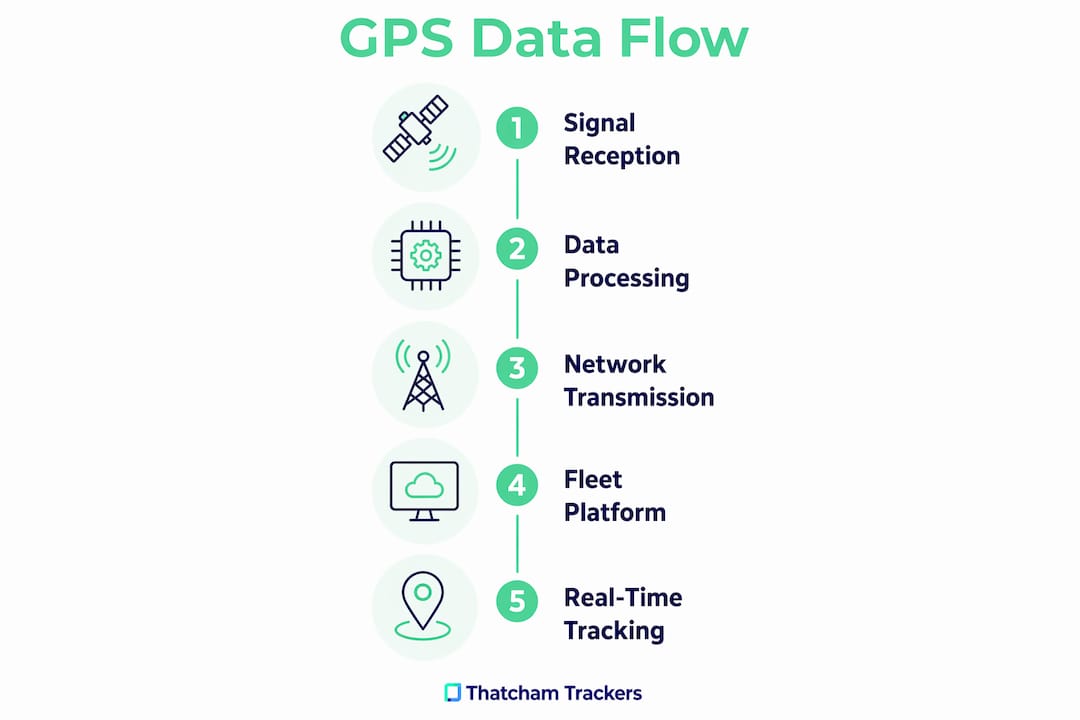
Capturing GPS and telematics data is only half the process. Getting that data to a fleet management platform reliably is where many systems succeed or fail. Transmission happens over cellular networks, with modern fleet devices supporting LTE Cat M1 for low-power, low-bandwidth updates and Cat 4 LTE for higher-volume data streams. The communication protocol used most widely is MQTT (Message Queuing Telemetry Transport), a lightweight messaging standard designed for unreliable networks.
The transmission process for a typical fleet event works as follows:
- Event trigger: The device detects a GPS position update, a harsh braking event, or a tachograph status change.
- Data packaging: The telematics unit packages the data point with a timestamp, vehicle ID, and priority flag.
- Network selection: The device selects the strongest available cellular network using a multi-network SIM.
- Transmission: Data is sent via MQTT to the cloud platform, where it is processed and displayed on the fleet manager’s dashboard.
- Buffering on signal loss: If cellular coverage drops, the device stores data locally and uploads it in sequence once connectivity resumes.
Professional fleet GPS devices use multi-network SIMs and intelligent software to prioritise critical safety messages during transmission. This means a collision alert reaches the platform before a routine position update, even when bandwidth is constrained.
Pro Tip: Specify a device with at least 72 hours of local data buffering. Remote rural routes and ferry crossings regularly produce extended coverage gaps, and unbuffered devices create holes in your audit trail.
Coverage reliability is also a growing concern for autonomous and semi-autonomous HGVs. Autonomous HGVs require hybrid connectivity combining 5G, satellite, WiFi, and emergency networks to maintain safety-critical communication. That same multi-channel approach is already appearing in advanced fleet trackers for conventional vehicles.
What are the regulatory requirements for GPS tracking in heavy goods vehicles?
GPS tracking in heavy goods vehicles carries specific legal obligations in the UK, and those obligations tightened significantly in 2026. The most material change is the Smart Tachograph 2 mandate. Since 1 july 2026, vehicles over 2.5 tonnes used for international hire must be fitted with Smart Tachograph 2, which includes enhanced anti-tampering measures, GNSS position recording, and remote enforcement capabilities.
The 56-day data retention rule is the compliance pressure point most fleet managers underestimate. Operators must retain tachograph records for 56 days and make them available for DVSA inspection on demand. Non-compliance results in journey stoppages and enforcement action. GPS tracking systems that integrate directly with digital tachograph downloads remove the manual download burden and reduce the risk of gaps in the record.
| Requirement | Detail |
|---|---|
| Smart Tachograph 2 fitment | Mandatory for vehicles over 2.5 tonnes on international hire from 1 july 2026 |
| Tachograph data retention | 56 days of records must be held and available for inspection |
| Remote enforcement | DVSA can interrogate Smart Tachograph 2 data roadside without stopping the vehicle |
| GVMS integration | GPS data must align with Goods Vehicle Movement Service statuses for UK-EU routes |
| Anti-tampering | Smart Tachograph 2 includes hardware and software measures against signal interference |
Lorry tracking systems integrate GPS data with Goods Vehicle Movement Service (GVMS) statuses and digital tachograph downloads, providing a single live picture per load. For UK-EU hauliers, this integration is the difference between a smooth border crossing and a delayed shipment.
What are the practical benefits of GPS telematics for large vehicle fleets?
The operational case for GPS telematics in large vehicles is well established. GPS tracking supports route optimisation, accurate ETAs, theft prevention, and driver behaviour monitoring, with measurable reductions in fuel costs and vehicle downtime. Each of these benefits compounds when GPS data is combined with telematics rather than used in isolation.
Route planning improves when the system accounts for vehicle-specific constraints. A 44-tonne articulated lorry cannot use the same roads as a 3.5-tonne van. GPS systems configured with height, weight, and axle restrictions route vehicles correctly from the outset, avoiding costly diversions and bridge strikes.
Driver behaviour monitoring produces some of the clearest return on investment. Harsh braking, excessive idling, and over-speed events are logged against individual driver profiles. Fleet managers can use this data to target coaching at the drivers who need it most, rather than applying blanket training programmes.
Emerging capabilities worth tracking for 2026 and beyond:
- Live customer-facing tracking portals: Modern logistics increasingly depends on live tracking portals and electronic proof of delivery to maintain competitive advantage.
- Predictive maintenance alerts: Telemetry sensors flag component wear before failure, reducing unplanned downtime.
- Autonomous HGV readiness: Hybrid connectivity combining 5G and satellite networks is already being specified for next-generation vehicles.
- Asset utilisation reporting: GPS data shows which vehicles are underused, enabling better fleet sizing decisions.
The commercial vehicle tracker guide from Thatcham Trackers covers how different tracker categories serve different operational needs, which is a practical starting point for fleet managers reviewing their current setup.
Key takeaways
GPS in large vehicles works by combining multi-constellation satellite positioning with CAN BUS telematics, cellular data transmission, and compliance integration to give fleet managers a complete, real-time picture of every vehicle.
| Point | Details |
|---|---|
| Multi-constellation GNSS | Using GPS, GLONASS, Galileo, and BeiDou together improves accuracy and signal reliability for large vehicles. |
| CAN BUS telematics integration | Connecting via CAN BUS J1939 gives access to engine, fuel, and fault data beyond basic location. |
| Data buffering on coverage loss | Devices must store data locally and upload in sequence to maintain a complete audit trail. |
| Smart Tachograph 2 compliance | Vehicles over 2.5 tonnes on international hire must carry Smart Tachograph 2 from 1 july 2026. |
| Operational ROI | Route optimisation, driver behaviour scoring, and predictive maintenance each reduce costs independently. |
GPS tracking in 2026: what fleet managers are still getting wrong
The technology works. The gap is in how fleets use it. At Thatcham Trackers, we see the same pattern repeatedly: operators invest in GPS hardware, then treat it as a theft-recovery tool rather than an operational data source. That is a significant missed opportunity.
The most underused capability is the link between telematics data and maintenance scheduling. A fault code appearing on a vehicle 200 miles from base is not just a warning light. It is a data point that, combined with GPS position and route history, tells a workshop manager exactly when that vehicle will arrive, what parts to have ready, and whether the driver should divert now or complete the delivery. Fleets that act on this data reduce unplanned downtime. Fleets that ignore it pay for it in recovery costs and missed SLAs.
Compliance is the other area where GPS integration is undervalued. The Smart Tachograph 2 mandate is not a box-ticking exercise. Remote enforcement means DVSA can read tachograph data without stopping the vehicle. Operators who have not integrated their GPS platform with tachograph downloads are carrying compliance risk they may not see until a roadside check. The 2026 best practices guide on insurance-approved trackers covers the security and compliance standards worth understanding before specifying new hardware.
The advice for fleet managers reviewing their GPS setup in 2026 is straightforward. Confirm your devices support CAN BUS J1939. Confirm your platform integrates with GVMS. Confirm your data buffering covers at least 72 hours. These are not advanced requirements. They are the baseline for operating a compliant, well-managed heavy vehicle fleet.
— Thatcham Trackers
Thatcham-approved GPS trackers for large vehicle fleets
Fleet security and compliance depend on the quality of the tracker fitted, not just the platform it connects to. Thatcham Research independently tests and certifies vehicle security systems, and insurance companies use those ratings to assess theft risk and set premiums.
Thatcham Trackers supplies insurance-approved GPS trackers across the S5 and S7 categories, both of which meet the standards required by major UK fleet insurers. S5-approved devices deliver real-time tracking with rapid position updates, making them well suited to high-value HGV and plant machinery operations. S7 devices add driver identification, which supports both compliance and driver behaviour programmes. All devices are compatible with existing fleet telematics platforms, removing the need to replace infrastructure already in place.
FAQ
How does GPS determine a large vehicle’s position?
GPS receivers in large vehicles measure the travel time of signals from multiple satellites and use trilateration to calculate a three-dimensional position. Professional fleet devices lock onto signals from several satellite constellations simultaneously to improve accuracy.
What is the difference between GPS and GNSS in fleet tracking?
GPS refers specifically to the US satellite constellation. GNSS is the broader term covering all satellite navigation systems, including GLONASS, Galileo, and BeiDou. Fleet trackers that use GNSS rather than GPS alone achieve better accuracy and reliability across varied routes.
What does Smart Tachograph 2 require from fleet operators?
Smart Tachograph 2 is mandatory for vehicles over 2.5 tonnes on international hire from 1 july 2026. Operators must retain 56 days of tachograph data and make it available for DVSA inspection, including remote roadside checks.
How does GPS data reach the fleet management platform?
Telematics units transmit GPS and vehicle data over cellular networks using protocols such as MQTT. Multi-network SIMs maintain connectivity across different network providers, and data is buffered locally when coverage is unavailable.
Do Thatcham-approved trackers work with existing fleet telematics systems?
Thatcham-approved S5 and S7 trackers are designed to integrate with standard fleet telematics platforms. They connect via established interfaces and transmit data to existing management dashboards without requiring a full system replacement.